Birth of the Military Grid Reference System and U.S. National Grid
A review of combat operations after WWII by the U.S. Defense Mapping Agency and similar organizations in NATO determined that there was need for a coordinate system other than latitude/longitude when precise and efficient location communications was a matter of life and death. Latitude and longitude coordinates had proven to be problematic in situations where an urgent response was needed. That's because latitude/longitude uses angular measurements difficult to estimate on maps, requires an extensive communication transmission which could be easily misspoken, transposed or incorrectly heard by the receiver, and didn't directly correlate to distances on the ground. Those limitations had caused navigation errors, delayed responses, and sometimes tragic outcomes during WWII.
To address this situation, in the late 1940's the U.S. Department of Defense and its NATO partners formally agreed to adopt the Military Gird Reference System (MGRS) for all ground operations going forward. Based on the worldwide metric coordinate system known as Universal Transverse Mercator (UTM), military planners had devised a way to create shorthand nomenclature for UTM which was teachable to an individual with an 8th grade education in 15 minutes. This modified UTM system is the MGRS.
After a series of significant hurricanes devastated the U.S. Southeast in the 1990's, it became apparent that in the interconnected world of modern infrastructure, mutual aid responders arriving from different parts of the country were going to need to be able to effectively and efficiently communicate location information using a standardized approach. To this end, in 2001 the Federal Geographic Data Committee formally adopted a slightly modified, but functionally same, version of the MGRS as the federal standard for this purpose. Released as the U.S. National Grid (USNG) standard, it has been subsequently endorsed by multiple federal, state and industry organizations as the approach which should be used when there is a need for an "emergency response language of location". With just 8 digits, a location can be pinpointed to within 10 meters in an area of 62x62 miles. It is also a system which works seamlessly with GPS and is more intuitive for individuals without formal navigation training.
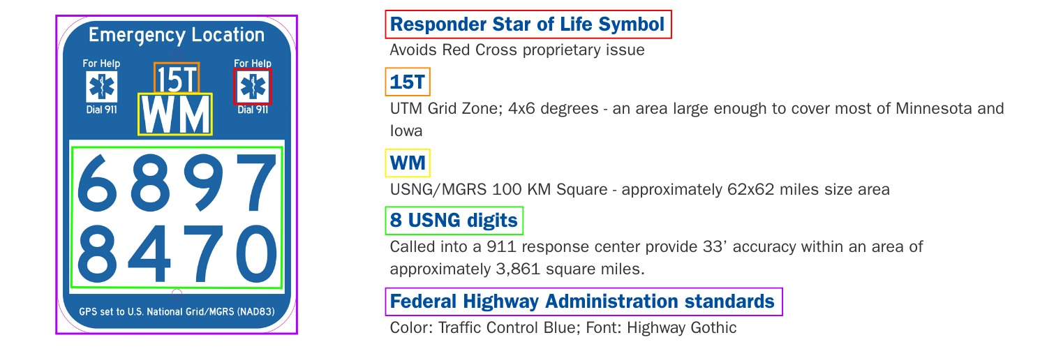
Emergency Location Markers (ELMs) translate USNG principles into a practical field application. After thorough testing with recreational users, responders, and geospatial experts, ELMs have been created for various use cases. Implementation across Minnesota, Florida, Iowa, Georgia and other states has significantly improved emergency response times by creating a consistent location reference system that works across jurisdictional boundaries.
The Parks and Trails Challenge for Emergency Responders

Designing the Solution
Result - The USNG Emergency Location Marker Is the Answer!

(Location as shown is a trail intersection on the Chester Park Trail, Duluth, Minnesota. Go there.)
