Find below some of the more frequently asked questions about the U.S. National Grid (USNG) and the nationally standardized Emergency Location Marker (ELM).
The Need: Challenges in Emergency Location
Locating someone on a trail or in a park is challenging for emergency services for several reasons:
The current generation cellphone location in most instances is derived from the GPS chip in that phone. Anything which degrades the phone's ability to "see" the GPS satellites will degrade the phone's location determination – inaccuracies which can be considerable. Examples:
- GPS tracking in buildings is basically nonexistent – this is a huge problem for 9-1-1 services as more and more individuals are using a cellphone as their only phone
- Forest canopy – same issue as a cellphone in a building; especially problematic in recreational trail environments
- Urban and natural canyons – a limited view of satellites by being in an area with a restricted horizon will result in an inaccurate location report
- Bad antenna – damage to the cellphone or wrapping it in a protective case can impact location determination
- Old technology – e.g. 1st generation flip phones; yes, they are still out there and they have no GPS chip
- Privacy concerns – Many users disable location tracking for legitimate privacy reasons. While 9-1-1 override capabilities exist in theory, call center issues may limit this capability in practice.
Furthermore, the location accuracy calculation is heavily impacted by the receiving system's capabilities. Is it a 9-1-1, E9-1-1, or NG9-1-1 system? And how well trained is the staff operating the call center?
Finally, Computer Aided Dispatch (CAD) systems default to latitude/longitude for cellphone location determination, which introduces an additional problem. There are three versions of latitude/longitude: degrees, minutes, seconds (D° M' S"); degrees, minutes, decimal minutes (D° M.M'); degrees, decimal degrees (D.D°). Confusion over which version is being used has sent rescuers to the wrong location with deadly results.
To illustrate this complexity, consider the coordinates for Mather Point at the Grand Canyon National Park in these three common formats:
-
Degrees, Minutes, Seconds (D° M' S"): 36° 03' 42" N, 112° 06' 29" W
-
Degrees, Minutes, Decimal Minutes (D° M.M'): 36° 03.702' N, 112° 06.480' W
-
Degrees, Decimal Degrees (D.D°): 36.06165, -112.10794
Emergency incidents in areas without street addresses are surprisingly common:
34% of U.S. response calls go to a location without a street address – recreational trails are a leading category. This statistic represents a significant portion of emergency calls that face the challenge of accurate location identification.
Nationwide adoption of NG911 has been slow and spotty, and many rural areas where recreational trails are located remain decades away from implementing. In addition, significant problems remain even in urban areas. Here are some examples:
- Emergency Disservice: Inside DC's Dysfunctional 911 System (Washingtonian - August 8, 2024)
- DC 911 Error Sends Fire & EMS to the Wrong Address on Cardiac Arrest Call (Statter 911 - May 7, 2022)
- If You Call Chicago 911 and Don't Know Your Street Address, Will the Dispatcher Send Help? (NBC 5 Chicago - December 11, 2019)
- 911 Can't Always Get Accurate Locations From Cell Phones (NBC Nightly News - Jan 11, 2018)
- With 2 Children Dead in Lilydale Park Landslide, Authorities Begin Asking Why?, (Pioneer Press - May 22, 2013)
These incidents impact both remote wilderness areas and urban parks, creating a significant challenge for emergency services nationwide.
 Locally unique marking systems have NO VALUE to responders unless those locations are READILY AVAILABLE in dispatch and response systems. This means your organization will need to constantly update and maintain your unique GIS information in police, fire, EMS, and ambulance service databases.
One example of how a local system can cause rescue problems occurred in 2010 in a 2,792-acre regional park in Minnesota: Mom, son and even rescuer lose their way at Lebanon Hills Regional Park (Pioneer Press - July 20, 2010).
Additionally, local numbering systems:
- Don't work with GPS like the ELM system.
- Don't facilitate a seamless recreational trail user experience – think "stop sign" value of the standardized ELM on trails in different locations – instantly recognizable.
- Don't integrate on intrastate and interstate systems crossing multiple jurisdictions. Appalachian Trail as an example.
- Don't employ the federal standard for all land-based search and rescue as endorsed by FEMA and the National Search and Rescue Committee – U.S. National Grid (USNG).
- Don't easily accommodate adding or deleting location markers. Since each ELM is associated with a unique location on the face of the earth, marker locations can be added or deleted without impacting the rest of the system.
- Don't exist as part of a larger, free national standard ecosystem of maps and apps.
- Don't efficiently empower trail maintenance teams to report specific locations needing work.
The Solution: Understanding USNG & ELMs
The U.S. National Grid (USNG) is a standardized geographic reference system adopted by the Federal Geographic Data Committee (FGDC) in 2001. It provides a nationally consistent grid reference system for the entire United States, dividing the country into equal-sized squares with a standardized coordinate format.
USNG is critically important for emergency response because it:
- Provides a consistent nationwide standard that works across jurisdictional boundaries,
- Uses a format that is compatible with GPS technology but doesn't require electronic devices,
- Creates human-readable coordinates that can be communicated verbally in emergency situations,
- Increases accuracy and precision in location reporting, reducing response times, and
- Is officially adopted by FEMA (FEMA Directive 092-5) and endorsed by the National Search and Rescue Committee for all land-based search and rescue.
The USNG system bridges the gap between technical GPS-based systems and human-readable reference points. By standardizing location information nationwide, it eliminates the confusion and dangerous delays that can occur when different organizations use different location reference systems.
As a real-world example, following Hurricane Katrina in 2005, emergency responders faced serious challenges with coordinating rescue operations due to inconsistent location reference systems. This experience helped drive FEMA's formal adoption of USNG as the standard for all emergency operations.
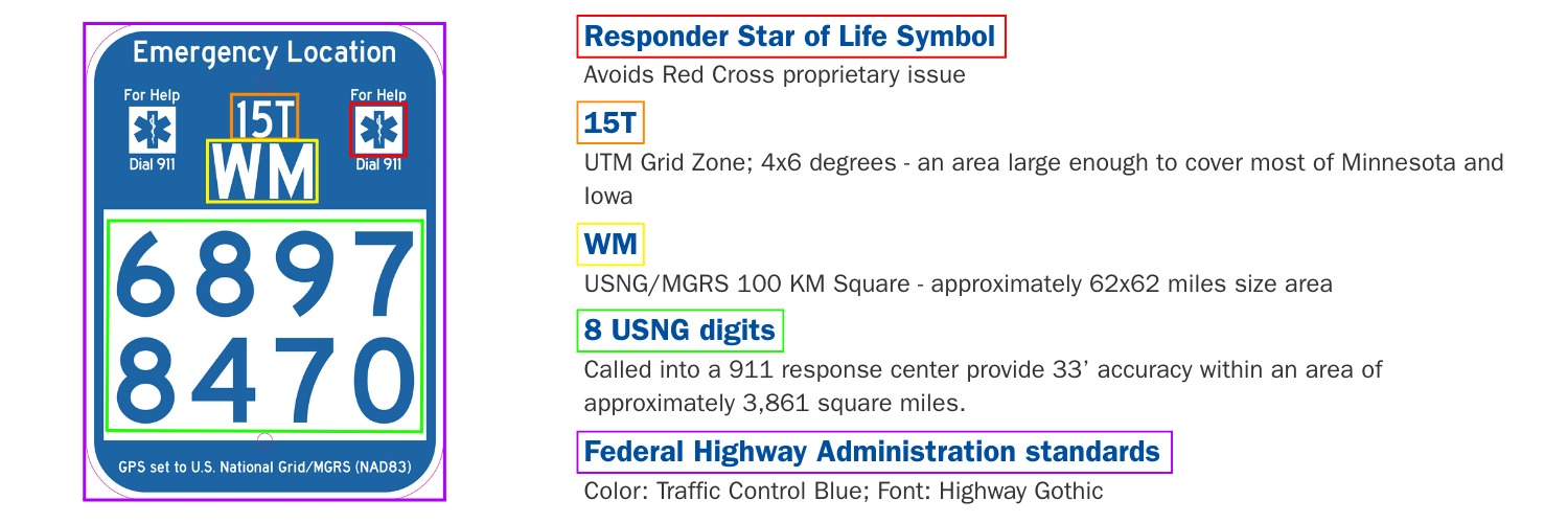
An Emergency Location Marker (ELM) is a physically installed sign that displays a standardized U.S. National Grid (USNG) coordinate at a specific location. The ELM system was developed to provide a consistent, recognizable marking standard for trails, parks, and other recreational areas nationwide.
Key features of an ELM include:
- The words "Emergency Location" prominently displayed at the top
- The "Star of Life" symbol (avoiding Red Cross proprietary issues)
- USNG coordinate components clearly displayed:
- Grid Zone (e.g., 15T)
- 100km Square ID (e.g., WM)
- 8-digit USNG coordinate (e.g., 6897 8470)
- Federal Highway Administration compliant colors and fonts (Traffic Control Blue, Highway Gothic font)
- Weather-resistant materials designed for outdoor installation
- Mounting hardware appropriate for various trail environments
ELMs provide an instantly recognizable reference point that can be verbally communicated to emergency dispatchers during a crisis. The standardized format ensures that regardless of where an emergency occurs, the location information can be quickly understood and acted upon by responders who may not be familiar with the specific trail system.
The USNG system provides exceptional accuracy for emergency location purposes in both wilderness and urban environments. An 8-digit USNG coordinate (standard on Emergency Location Markers) provides accuracy to within approximately 33 feet (10 meters) within approximately 3,861 square miles - precise enough for emergency responders to locate someone in distress, whether in dense forest, urban parks, or anywhere in between.
This level of precision works well in emergency situations because:
- It narrows the search area to a very manageable size
- It's simple enough to communicate over phone or radio
- It's consistent nationwide, eliminating confusion between jurisdictions
- It doesn't rely on proprietary systems or technology
USNG also offers flexible precision depending on your use case:
- 6-digit coordinates (100-meter accuracy) work ideally for helicopter landing zones
- 10-digit coordinates provide 1-meter (3.3 feet) accuracy when needed
USNG coordinates have been shown to reduce search times compared to traditional landmark-based descriptions, potentially saving lives when every minute counts.
USNG and Emergency Location Markers (ELMs) significantly improve emergency response in outdoor areas through several key mechanisms:

- Standardized Location Communication: Instead of trying to describe a location with landmarks or approximations ("about a mile past the big oak tree"), a caller can provide an exact USNG coordinate from an ELM, eliminating confusion.
- Cross-Jurisdictional Compatibility: When emergencies occur in areas bordering multiple response jurisdictions, USNG provides a common "language" for location information that all agencies understand.
- Reduction in Response Time: Precise location information can significantly reduce emergency response times in outdoor settings, potentially making the difference between life and death.
- Improved Resource Allocation: Knowing the exact location allows emergency managers to dispatch the appropriate resources via the most efficient route, avoiding wasted time and effort.
- Reduced Dispatcher Confusion: Dispatchers can immediately plot USNG coordinates on maps without needing to interpret vague descriptions or convert between different coordinate systems.
USNG is designed to function completely independently of cellular or internet connectivity:
Physical Implementation:
- Emergency Location Markers (ELMs) with USNG coordinates are permanently installed on trails
- Paper maps, such as the US Topo series, produced by the USGS, with USNG grid overlays, work without any technology. See instructions for downloading official maps with USNG coordinates using topoView.
- Compass and map skills allow navigation using USNG grid references
- Verbal communication of USNG coordinates works via radio or in person
Technology Integration:
- Progressive web applications like USNGapp.org work offline after initial loading
- Handheld GPS units display USNG/MGRS coordinates using satellite signals only
- Offline mapping apps can display USNG grids with pre-downloaded maps
This independence from connectivity is crucial for areas where cellular service is limited or nonexistent. According to the Federal Communications Commission, a significant percentage of rural America lacks reliable cellular coverage, making technology-independent systems essential for safety.
This dual nature – functioning with technology and without it – makes USNG uniquely resilient for emergency scenarios.
USNG & ELMs in Practice
Installing Emergency Location Markers (ELMs) effectively involves careful planning and adherence to recommended practices to ensure they are visible, durable, and reliable for emergency response. ELMs are typically installed strategically at:
- Trail intersections and junctions
- Trailheads and access points
- Regular intervals along trails (often around every half-mile to mile)
- Areas with higher potential for incidents or confusion (e.g., steep sections, water crossings, complex trail segments)
- Key decision points or areas of particular scenic interest
The physical implementation process includes several key steps:
- Planning Phase: This involves detailed GIS mapping to determine the optimal placement and the accurate USNG coordinate for each marker based on its intended purpose, the terrain, and accessibility for responders.
- Coordination: Collaborating closely with relevant land management agencies (such as the National Park Service, state parks, or local authorities) is essential to secure necessary approvals and ensure compliance with their specific regulations.
- Choosing the Right ELM and Mounting System: Selecting the appropriate type of ELM and corresponding mounting hardware is crucial for long-term effectiveness. ELMs are available in various forms, including rigid markers designed for post mounting and durable stickers intended for retrofitting existing, sturdy trail infrastructure.
- Installation: Markers should be installed at standardized, easily readable heights (typically eye-level) and oriented correctly to face the primary direction(s) of approach on the trail for maximum visibility.
ELM Consultants with proven implementation experience can provide valuable guidance throughout a project. For selecting the most appropriate ELM type and mounting hardware for your specific trail environment and project needs, these specialists offer technical support from initial planning through final installation. This is discussed in further detail on the Installation Planning Steps page.


Emergency responders use USNG coordinates during rescue operations in several key ways:
- Dispatch Communication: When dispatch receives a call with a USNG coordinate (from an ELM or app), they can immediately pinpoint the exact location without confusion or the need for conversion.
- Search Planning: Incident commanders can divide search areas into USNG grid cells, systematically assigning teams to specific grid squares.
- Field Navigation: Responders can navigate directly to coordinates using USNG-compatible GPS devices, printed maps with USNG grids, or specialized apps.
- Multi-Agency Coordination: When multiple agencies respond to incidents, USNG provides a common "language" for location, eliminating confusion between different systems.
Additionally, many search and rescue organizations have adopted USNG as their standard coordinate system for field operations.
Unlike a localized trail marking system, USNG can still help find an individual who is off-trail or away from an ELM, provided they have some means of determining their location:

- Smartphone Apps: Apps like USNGapp.org provide USNG coordinates anywhere, even without cellular service (after initial loading). The app displays your location in the same format as an ELM, making it easily communicable to emergency services.
- GPS Units: Almost every GPS unit can display USNG coordinates (sometimes listed as MGRS). Hikers can relay these coordinates via voice call or text message if they have even minimal cell service.
- Paper Maps with USNG Grid: Prepared hikers can carry maps with USNG grid overlays, allowing them to determine approximate coordinates using map-reading skills. The US Topo series, produced by the USGS, include USNG grid references, providing a reliable backup for navigation when electronic devices fail or battery power is unavailable. See instructions for downloading official maps with USNG coordinates using topoView.
- Search Area Definition: Even if the exact location isn't known, USNG provides a standardized way to define search areas. Instead of saying "somewhere on the north ridge trail," searchers can focus on specific USNG grid squares.
This capability makes USNG superior to physical marker-only systems, as it provides universal location capability regardless of proximity to installed infrastructure.
USNG vs. Other Location Methods
The merits of the underlying U.S. National Grid and ELM system over these alternate approaches are substantial:
- In each commercial instance, you are BUYING into another entity owning your "where" capability, which places you on a developmental dead-end limited by what the provider will deliver.
- USNG is the free federally endorsed standard for SAR and response which invites follow-on innovative development.
- Proprietary approaches don't work with GPS. USNG and ELMs do.
- Proprietary approaches are NOT part of a bigger eco-system of maps and apps as is the case with ELMs – these other proprietary products are their own self-standing "thing."
- USNG/ELM coordinates mean something intuitive – Cartesian, distance based – which is why this approach has been used by U.S. and NATO armed forces worldwide since the late 1940's.
- USNG/ELMs provide spatial context/awareness and shows relations to objects.
- Scalable – USNG works to describe locations ranging from submeter to multi-state, this is not possible with these other systems.
- USNG/ELMs work with, or without apps, computers or electricity.
Many mountain rescue organizations have specifically warned against relying exclusively on proprietary systems like What3Words due to concerns about accuracy and dependency on a single company's services.
Moreover, the Open Geospatial Consortium has consistently advocated for open standards like USNG rather than proprietary alternatives to ensure long-term accessibility and interoperability.

USNG and traditional latitude/longitude coordinates represent two fundamentally different approaches to location referencing:
USNG Coordinates:
- Based on a grid system with equal-sized squares
- Uses alphanumeric format (e.g., 15T WM 6897 8470)
- Designed for human readability and verbal communication
- Standardized format nationwide
- Naturally increases in precision as more digits are added
- Works directly with paper maps that have the USNG grid without conversion, such as the US Topo maps, produced by the USGS.
Latitude/Longitude Coordinates:
- Based on angular measurements from the equator and prime meridian
- Uses decimal degrees (e.g., 46.8122, -92.0960) or degrees-minutes-seconds
- Exists in multiple formats (D.D°, D° M' S", D° M.M') causing potential confusion
- Less intuitive for verbal communication or manual plotting
- Requires more training to use effectively without technology
Emergency responders using USNG coordinates are often able to locate targets more quickly than those using latitude/longitude coordinates in field exercises, particularly when communications are limited to voice only.
The practical advantage of USNG becomes particularly clear in emergency situations where simplicity and standardization are critical for rapid communication. While a full USNG coordinate like "15T WM 6897 8470" pinpoints a precise location, in a local area or during an incident, responders often only need to communicate the 8-digit Easting and Northing (e.g., "6897 8470"). This is because the initial grid zone and 100,000-meter square are understood within the operational area. This makes communicating a location significantly easier, faster, and less prone to errors over a radio compared to trying to relay potentially confusing and more complex formats like:
-
Degrees, Minutes, Seconds (D° M' S"): "46 degrees, 48 minutes, 44 seconds North, 92 degrees, 5 minutes, 45 seconds West."
-
Degrees, Minutes, Decimal Minutes (D° M.M'): "46 degrees, 48.737 minutes North, 92 degrees, 5.758 minutes West."
-
Degrees, Decimal Degrees (D.D°): "46.8122 degrees, negative 92.0960 degrees"
USNG offers several advantages over traditional mile marker systems on trails:
USNG Advantages:
- Universal Reference: USNG coordinates are meaningful
 anywhere in the country, not just on a specific trail.
 - Precision: Provides accuracy to within 10 meters, regardless of where you are on or off the trail.
- Orientation: Provides both location and directional context within the larger landscape.
- Multi-use: Can be used with maps, GPS devices, smartphones, or paper references.
- Interoperability: Compatible with military and first responder systems nationwide.
 anywhere in the country, not just on a specific trail.
Traditional Mile Marker Limitations:
- Linear Only: Only meaningful on the specific trail; meaningless if you're off-trail.
- Ambiguous: "Mile marker 3" could be on any trail in any park system.
- Non-standardized: Numbering systems vary widely between trail systems.
- Limited Context: Provides only linear position, not location in broader geographic context.
- Maintenance Issues: If markers are added/removed, entire trail may need renumbering.
Yes, USNG can be readily integrated with existing maps and navigation systems through several methods:
For Physical Maps:
- USNG grids are incorporated directly onto certain paper maps, including on the US Topo series, which is the current USGS topographic map series for the Nation. See instructions for downloading official maps with USNG coordinates using topoView.
For Digital Systems:
- Mapping platforms such as ESRI (ArcGIS), QGIS, and Google Earth support USNG grid overlays
- GPS manufacturers including Garmin, Magellan, and Trimble support USNG/MGRS format
- Popular hiking apps like Avenza Maps, CalTopo, Gaia GPS, and can display USNG coordinates
For Agencies and Organizations:
- Existing GIS databases can convert coordinates to USNG format without changing underlying data
- Trail mapping systems can maintain current numbering while adding USNG references
- Dispatch systems can be configured to accept and display both traditional and USNG coordinates
Apple's Emergency SOS via satellite is a valuable technology but serves a different purpose than USNG and does not replace the fundamental need for standardized location markers:
Emergency SOS via Satellite Considerations:
- Only available on iPhone 14 or later models.
- Requires functioning phone hardware and battery power.
- Limited to areas with a clear, unobstructed view of the sky for satellite connection.
- It is a proprietary system controlled by a single company.
- Currently offered free for a limited time with eligible devices, but is expected to require a paid subscription in the future, making its long-term availability dependent on payment.
USNG and ELM Advantages:
- Works with or without technology (physical markers, paper maps with grids, map and compass).
- Is a universal system not dependent on any particular device, brand, or service plan.
- Accessible to anyone, regardless of phone ownership or model.
- Not dependent on battery power or functioning electronics.
- Is a non-proprietary, federally endorsed standard compatible with all emergency service systems nationwide.
- Provides location context and a framework for navigation even without electronic connectivity.
Emergency management organizations consistently recommend a layered approach to emergency location and safety. USNG serves as the resilient foundation because it provides a method that works universally and is independent of technology availability or status.
While Emergency SOS via satellite is an excellent technological enhancement that provides a communication channel for certain users in specific situations, it builds upon, rather than replaces, the universal standard provided by USNG. The most robust safety system incorporates both: promoting the understanding and use of USNG for universal standardization and resilience, and leveraging technology like Emergency SOS via satellite when compatible devices and conditions allow.
Getting Started: Implementation & Access
No!
The underlying U.S. National Grid is a non-proprietary cartographic and response standard of the U.S. federal government. Similarly, SharedGeo is a federally recognized nonprofit which retains copyright on the ELM design to ensure it remains in the public domain. If desired/requested, SharedGeo will issue to any entity with trail ownership/operating authority a letter stating SharedGeo releases in perpetuity the authorization to use the design in the entities' area of responsibility.
SharedGeo's only reason for placing copyright on the ELM design is to ensure it can serve as concept guardian and prevent a commercial lockout/exploitation of trail organizations at some point in the future.
Virtually all supporting documentation SharedGeo has developed for the ELM system is available for free under Creative Commons licensing. Additionally, SharedGeo has developed several USNG/ELM apps which are available to the public for free.
 Park systems and trail organizations can implement USNG and ELMs through the following process:
- Initial Planning:
- Contact an ELM Consultant for implementation guidance
- Review the USNG Implementation Guide
- Identify key stakeholders (land managers, emergency services, trail maintenance)
- Assessment and Mapping:
- Conduct GIS mapping of trail system to identify optimal marker placement
- Generate USNG coordinates for each proposed marker location
- Review placement strategy with emergency services agencies
- Implementation:
- Order standardized ELMs through ELM Distributors
- Coordinate installation with trail maintenance teams
- Register marker locations with local emergency dispatch centers
- Education and Outreach:
- Train staff on the USNG system
- Update trail maps and brochures to include USNG information
- Develop educational materials for visitors
- Conduct outreach to local emergency services
This process is discussed in further detail on the Installation Planning Steps page.
Explore various USNG resources available to the public, categorized for easy access:
-
For key documents, endorsements, training materials, and other foundational information, see the Reference Items page.
-
To learn about Emergency Location Marker (ELM) installations, visit the the Installation Planning Steps and Ordering Information pages.
-
For complimentary, free web tools, online resources, and printable guides, check the Free Resources page.